Geological Foundations of the Canadian Rockies
Canadian Rockies
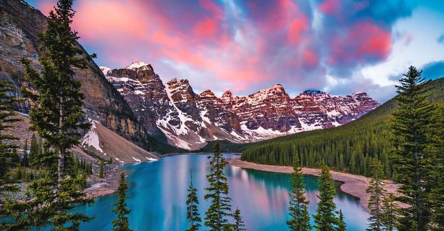
You might be surprised to learn that although the Canadian Rockies lie in the interior of North America, their rocks were born in shallow ocean environments. Much of the continent was under water at the same time Tyrannosaurus Rex and Triceratops roamed about, and that’s when a lot of the rock in this area was formed. Some rocks are even older. If you look at maps of the area today, you’ll notice that the word ‘reef’ appears not infrequently, indicating the presence of rocks that contain fossils of sea life that lived in these shallow ocean environments in Devonian times. All these sedimentary layers rest upon ancient basement rocks, which are part of the Canadian Shield and are some of the oldest rocks on the entire planet.So how did these oceanic rocks become mountains? And how did a mountain range end up in the middle of a continent anyhow? A common analogy goes like this: imagine a rug on a hardwood floor. If you were to push the rug from one edge with your foot, the rug would begin to fold and buckle. That’s exactly what happened as the Kula continental plate crashed into the North American plate ages ago. The overlying sedimentary layers behaved like the rug, folding and buckling, piling ridges up against one another as they were pushed over the top of the underlying Canadian Shield rock.
Today, that mountain-building event has left a series of parallel mountain ranges that generally run from northwest to southeast, spanning over 1,000 miles. The peaks on the western side of the Canadian Rockies are higher than in the east, reaching their zenith atop Mt Robson at 12,972 feet in elevation. Those western ranges also form the continental divide, separating waters that flow westward into the Pacific from those flowing northwards and eastwards into the Arctic Ocean and Hudson Bay. The mountains are steep and formidable, and it is possible to travel between the eastern and western regions in only a few places, with the help of great valleys leading up to high mountain passes.
The Bugaboo Mountains
Looking at a map, it’s easy to think that the Bugaboos are part of the Rockies. But according to Canadian geologists, they are two separate ranges. This is because the Bugaboos, part of the Purcell Mountains, which are themselves part of the larger Columbia Mountain group, lie on the western side of the Rocky Mountain Trench. The trench is an enormous 1,000-mile-long valley that was created by geologic faulting. The mountains here have different origins, particularly the Bugaboos themselves.The spectacular spires of the Bugaboos lunge toward the sky, belying their origins deep within the Earth. They are plutonic rocks, formed from liquid magma. At different times, various chambers of magma cooled into a rock called granodiorite (similar to granite). Eventually, several of these formations- known as batholiths- were heaved upwards, penetrating through the rocks at the Earth’s surface. Over time the original surface rock eroded, leaving the batholiths behind as otherworldly spires that reach up to the heavens.
Canyons and Caves
Historically, it was common for pioneers to follow river systems as they explored and discovered new areas. In the Canadian Rockies, they were searching primarily for beaver, gold and other precious minerals. You can imagine their surprise when some of the rivers and creeks they followed quite literally led them deeper into the mountains, to the entrances of deep caves and narrow canyons. You’ll have the opportunity to follow in the footsteps of some of these pioneers; to explore scenic river canyons that are etched into the Earth.The presence of these caves and canyons is possible thanks to a very specific rock type that is common to the area: limestone. Karst is a word that you’ll likely encounter while you’re here, and it simply describes a landscape formed by the dissolution of limestone.
Limestone is notable in that it is formed underwater via chemical processes in very shallow seas. When water is re-introduced to the rock- particularly water that has a slight acidity—limestone easily dissolves back into the water. Water enters limestone rock through a network of cracks that function much like a plumbing system. Over time, the effect is a widening of these plumbing channels as the limestone is eroded by the water, resulting in winding passageways of all shapes and sizes.
In addition to famous river gorges like Johnson Canyon in Banff National Park and Maligne Canyon in Jasper National Park, there are some other remarkable caves found in the area. The largest explored system is Castleguard Cave, which lies within Banff National Park and contains over 12 miles of twisting passages (this cave system is located in a protected area and access has been restricted since the 1970s). Further north in Jasper National Park, there is likely a much larger cave system, though it is still flooded with water and remains inaccessible. We know of it because of an intriguing connection to Medicine Lake. This lake has no outflow but instead loses its water to the subterranean world. Each spring this large lake floods as snowmelt arrives from higher elevations, and by summer the lake drains again, hinting at the immense capacity of these underground cave networks.
Glaciers
Water comes in every form here, and perhaps none is more spectacular than that of ice. Some of the most impressive glaciers in North America lay within the Canadian Rockies, including the famed Columbia Icefield. This enormous sheet of ice spans the high mountain environment of Banff and Jasper parks, fully blanketing an area of 125 square miles. It is 1,200 ft thick at its deepest point and has six major glacial tongues that pour into the expansive valleys below. The most famous of these is the impressive Athabasca Glacier, which you’ll visit during your time here.The Athabasca Glacier showcases everything you’d want to know about glaciers, from how they form to how they move, and even how they feel. You’ll peer down into deep blue crevasses and witness lateral moraines—the rock debris left behind as the colossal glacier bulldozed its way downhill. You’ll also see for yourself how the glacier itself has changed since guests like you first came to visit many years ago.
Glaciers connect us to past climates. Since glaciers are a product of climate, we can expect to see changes in the glaciers as our planet’s climate changes. Over the past 125 years, the Athabasca Glacier has receded significantly. Around 1900, you would have encountered it right next to the road. Today it resides a mile up the valley and is receding by approximately 16 feet per year. As you hike or ride to the Athabasca Glacier, notice the historic markers that show where the glacier used to end. The recession of this, and other North American glaciers, is directly linked to rising temperatures.
You can imagine that the entire region experienced something similar at the end of the great ice ages. As the climate warmed, glaciers shrunk and retreated to the highest mountains, exposing barren and rocky landscapes. In the wake of the recession, lichens and cold-hardy vegetation took hold first. Nutrient-rich soils eventually formed, and the land transitioned into sprawling meadows which attracted herbivores. Finally, forests sprung up, leading to the diversity that we experience today.


